Historic settlements above Elsdon Burn
- Feb 2, 2024
- 4 min read
Updated: Jun 14, 2024

The entire northern area of the Cheviot hills is full of history, littered with Bronze and Iron Age hillforts and settlements, standing stones, stone circles, abandoned medieval villages and farms, fortified households, ruins of illicit whisky stills, ancient drove roads, disused railway lines, and WWII airplane crash sites. It tells a story of continuous human activity through centuries, of quiet, prosperous, and turbulent times. There is plenty to explore here, and there is something magical in travelling through this landscape, in the footsteps of our ancestors.
The lovely College Valley is one of the five Cheviot valleys (College, Harthope, Breamish, Bowmont and Heatherhope). It is named after the College Burn which originates in the Hen Hole gorge on the east side of The Cheviot massif and meanders through the valley. The Cambridge Dictionary of English place-names suggests that the name of the burn means either "cold stream" from the Northern dialect word "letch" meaning "a stream flowing through boggy land" or from "col" as in "charcoal", meaning "the stream where charcoal is burnt".
Hethpool used to be a thriving village in the medieval times, with its own chapel, mill and a brewery. As a border hamlet it did suffer quite a bit of damage in the Scottish-English wars and the reiver raids, but the mill and some of the old farm buildings in the valley still remain, and medieval cultivation terraces can be seen on the nearby hills, including on the White Hill north of the Hethpool village. The Hethpool car park however shows a glimpse of even older human history. The car park is located next to the remains of two large stone circles, dating from about 2500 BCE. The Historic England records state “Two stone circles located on a gravel terrace at the head of the College Valley. The visible stones form a ruinous circle to the S whilst a group of outlying stones lie to the N. At least seven stones are recumbent. A further six stones associated with the N group have been located below ground by probing. The evidence thus acquired suggests that the monument originally took the form of two closely spaced stone circles. The maximum height of the stones is 1m and several of them exhibit small chock stones wedged around their bases in order to keep them upright. This would suggest that they are still in their original position. The S circle has a diameter of 61m by 42.7m with an average interval of 16m-20m between each stone, including those found by probing. The N group measures about 60m by 45m”. It must have been an impressive site in its heyday, and seen in all its glory from the surrounding hillforts of Black Haggs Rigg, Sinkside, Great Hetha, Little Hetha and Ring Chesters.

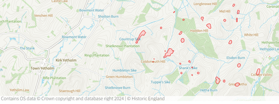
A map of scheduled monuments around Elsdon Burn (Historic England)
It is strange to think that these remote hills were once a hive of human activity. In the Elsdon Burn valley, studies of the settlements and cairns east of Laddie’s Knowe produced evidence of human activity from 2000-500 BCE, and the homestead next to these is a later Romano-British addition. North of Laddie’s Knowe there are more ancient settlements, this time a house from the Bronze Age and a Romano-British settlement of at least 7 huts. The nearby defensive Iron Age hillfort of Ring Chesters was also occupied during the Roman period, and the defensive settlements North and South of the fort and in Scaldhill Shank are classic examples of Roman period defensive settlements. Between the Ring Chesters and Coldsmouth Hill lies another hut circle, which was also inhabited in the Romano-British times. In the medieval period this site was recorded as Heddon village, and it was most likely abandoned in early XVI century. Farming furrows and outlines of several buildings can still be seen, telling a story of a once thriving community. The nearby Coldsmouth Hill contains two prehistoric cairns at the Northern and Southern end of the summit. These are well preserved examples of Bronze Age burial mounds, which were excavated in the 1920s and produced cremated human remains, a flint tool, a flint saw and a bronze dagger. Ell’s Knowe nearby is home to a rare Iron Age palisaded hilltop enclosure (there are only about 200 of these known in Britain) dating to c.550-440 BCE. The Iron Age Hillfort of Great Hetha contains 9 circular huts and rises above the stone circles down in the College Valley, suggesting that there may have been a settlement there in the earlier times as well. Below, there is a Romano-British settlement and Little Hetha, another Iron Age defended settlement which most likely was occupied well into the medieval times.
It is unclear why the Bronze and Iron Age people chose to live in the hillforts rather than in the valleys below. It is also not fully understood why Northumberland contains the highest concentration of hillforts in Britain. One of the suggestions is that the hillforts had a defensive function, protecting people during intense intertribal conflict. However, the excavations haven't really produced evidence of this. Bronze Age Britain was densely forested and full of dangerous predators, perhaps the farmers have simply chosen higher ground and palisaded enclosures as safety measures in this hostile environment? It is also possible that some of the forts were residential whereas others had a more ceremonial function. The studies are still ongoing. Wouldn't it be amazing though to go back in time, and see the Cheviot hills teaming with people, or join them in a ceremonial procession to the stone circles in the College valley?
Our walk route:
Comentarios